GAF AG has been involved in designing, implementing and shaping the remote sensing-based control of subsidy applications submitted under the European Common Agricultural Policy (CAP) for 30 years. This delegation of public tasks to the earth observation sector, which is unique in its scope of application, is now being replaced by a fully comprehensive, automated monitoring system, called AMS. For the operational implementation of this new control concept, GAF is again involved in the technological and methodical development, with for example AI and cloud solutions, right from the very start.
When GAF ran a pilot project to check applications relating to durum wheat and cotton in Greece in 1990 on behalf of the EU, and then checked applications for 5-year set-aside in Germany, the foundations were laid for the subsequent continuous implementation of controls relating to area-related measures in the European member states using remote sensing methods.
On the basis of these and other pilot projects, the EU Commission confirmed the technological acceptance of remote sensing controls as an equivalent procedure to on-site controls in the 1992 reform of the CAP, as well as in all subsequent reforms. Since then, GAF has taken on responsibility for the subsidy-control tasks in various German federal states and has also been involved in performing similar controls in other European member states, as a delegated assignment of the relevant paying agencies.
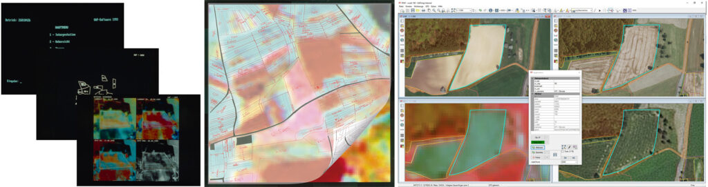
The past 30 years have been characterised by major developments in the data that is used (e.g. from analogue cadastral maps to digital automated parcel maps (ALK) and agricultural reference cadastres), the technology (e.g. spatial resolution of satellite data of 10m, 5m, 1m and now 30cm) and an increase in the regulatory requirements (from using remote sensing as a correctness filter to equating remote sensing with on-site controls and thus having a 0% error tolerance).
These spot checks, which are based on the interpretative evaluation of high-resolution satellite data and digital orthophotos, are now being replaced by a new control concept. As part of the modernisation and simplification of the CAP, the European Commission has decided to introduce a new, comprehensive, continuous and automated area monitoring system, based on the Copernicus programme’s Sentinel constellation, to check subsidy payments.
GAF also acted at an early stage with regard to this new Area Monitoring System (AMS), by investing in technological and methodological development with AI and cloud solutions. As a result, the company has been continuously assigned corresponding pilot projects in various federal states since 2018. In addition, since 2021 GAF has had the task of performing the first operational implementation of the AMS in Germany, and has been awarded contracts by several federal states based on EU-wide tendering procedures.
GAF will be presenting all its innovations, individual solutions and applications from 18-20 October at Intergeo 2022.