Challenge
To procure, visualise and disseminate high quality and up-to-date 3D geoinformation about urban areas and critical infrastructure worldwide.
Solutions created by GAF Geospatial GmbH
GAF Geospatial GmbH (GAF) provides worldwide 3D geoinformation as well as a high-performance 3D GIS software, based on its expert knowledge of the requirements of governmental and military customers:
- GAF Elevation Suite: GAF produces very high and high-resolution imagery, digital elevation models and other 3D derivatives such as building (block) models with spatial resolutions of between 0.3 m and 10 m – based on a multitude of current Earth Observation (EO) satellite systems, using archive or recent satellite data.
- GAFmap®: GAF’s Desktop GIS software supports realistic (multi-user) 3D and VR visualisation – including for large data quantities and offline scenarios. With the Pack&Go and GAFmap® Express extension, simulations can easily be shared with team members and partners.
Customer Benefits
- Skilled provider of comprehensive satellite data services and products. The company’s independence allows it to have a neutral approach to selecting the best data and products for the customer requirements.
- Rapid provision of elevation products on request or from stock possible for areas all over the world.
- Optimised data availability through the use of different satellite systems.
- Best possible spatial resolution, horizontal and vertical accuracy as well as object representation for satellite-based elevation products and 3D geoinformation.
- Reliable, reproducible, high-quality 3D information especially suited for sophisticated object and spatial analysis, including change detection.
- Customisation of standard products and post-processing.
- Additional data delivery formats and GIS software optimised for 3D and VR visualisation.
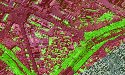
© 2020, GAF AG, © CNES (2019), Distribution AIRBUS DS
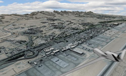
© 2016, GAF AG, © Maxar Technologies (2016), supplied by European Space Imaging